Avalanche forecaster: Abundance of snow can be less risky, in the long run, than scarcity
Published 5:00 am Saturday, January 4, 2025
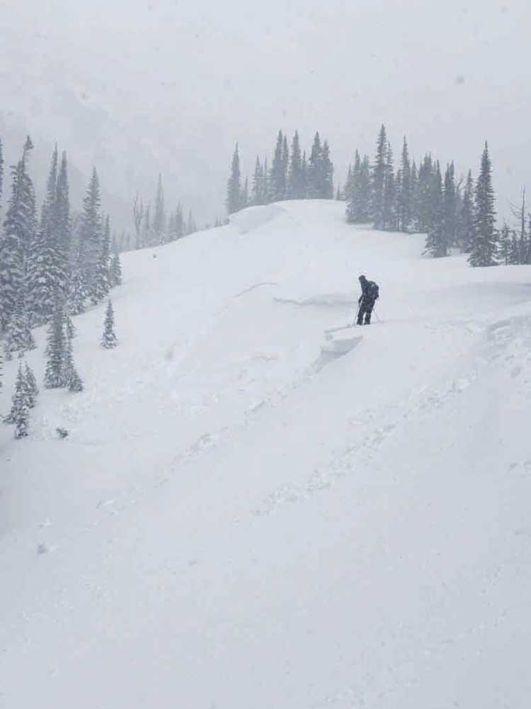
- A backcountry skier tests a slope for stability in the McCully Basin area southeast of Joseph on Jan. 3, 2025.
A barrage of blizzards since Christmas temporarily increased the avalanche danger in parts of Northeastern Oregon in late December, but a local avalanche forecaster said the abundance of snow can actually be less hazardous than a scarcity.
The recent storms, which dropped close to 4 feet of new snow in the southern Wallowas and around 3 feet in parts of the Elkhorns, combined with persistent wind to create snow slabs where avalanches were possible, said Caleb Merrill, a forecaster with the Wallowa Avalanche Center in Joseph.
Those conditions, and snowy forecasts from the National Weather Service, prompted the avalanche center to issue warnings in late December for the southern Wallowas and for the Elkhorn Mountains.
(The latter warning didn’t apply to Anthony Lakes Mountain Resort, where ski patrollers monitor avalanche conditions and, when necessary, trigger small slides before opening the area each day.)
All warnings ended Dec. 30.
As of Monday, Jan. 6, no warnings were in effect. The Wallowa Avalanche Center rated the avalanche danger as low below the treeline, and moderate at and above the treeline, around Northeastern Oregon.
Merrill, who has worked in Northeastern Oregon during the past four winters and moved recently to Enterprise, said the comparatively tranquil weather forecast should allow the new snow to become more stable and less susceptible to sliding.
Merrill recommends that backcountry travelers, including snowmobilers, cross-country skiers and snowshoers, dig down 2 to 3 feet into the snow to look for potential weak layers before traveling across avalanche-prone terrain.
“Seek out small and inconsequential test slopes that will give you important information on the sensitivity of wind slabs,” Merrill wrote on the avalanche center’s website on Dec. 30 (wallowaavalanchecenter.org). “Avoid wind-loaded avalanche paths.”
When wind blows for extended periods it can, in effect, “beat up” the snowflakes, breaking them into smaller pieces, Merrill said. The snow grains can pack tightly into slabs that can slide, particularly if a snowmobile rider or skier puts pressure on the slab.
Wind slabs can form anywhere, but they tend to be prevalent on the leeward side of slopes, just below cornices, Merrill said.
Although the parade of post-Christmas storms temporarily increased the avalanche danger in the southern Wallowas and Elkhorns (there was relatively less new snow in the northern Wallowas and northern Blues, so the avalanche center didn’t issue any warnings for those areas), the situation is less concerning than the conditions that have prevailed for much of the previous two winters, Merrill said.
In those seasons, extended periods of cold, dry weather led to a layer of “sugary” snow with grains that didn’t latch together and were unstable, Merrill said.
When snow accumulated on that layer, the risk of avalanches was relatively high, Merrill said.
And that danger continued for weeks due to the persistently dry weather in those winters — what Merrill called a “classic persistent slab problem.”
This winter, a layer of relatively unstable snow formed during the dry stretch between Thanksgiving and the first week of December, Merrill said.
“We believe the trend with this layer is that it is gaining strength, but we are not yet ready to turn our backs on it,” he said.
About the Wallowa Avalanche Center
The organization was started in 2009, and although it doesn’t get any government subsidies, a couple years ago the center doubled its number of forecasts from two to four per week, focusing on the busiest period for backcountry travel — Thursday through Sunday.
The center’s forecasters issue forecasts for each of four zones in Northeastern Oregon — Northern Blue Mountains, Elkhorns, Northern Wallowas and Southern Wallowas.
Victor McNeil, the center’s director, said in a previous interview that dividing the region into zones is necessary because the avalanche danger, and snowpack conditions, can vary widely.
The Wallowas, for instance, are separated into northern and southern zones because in general the southern Wallowas get quite a lot more snow than the northern part of the range.
The post-Christmas storms illustrate the difference.
As of Jan. 6, the snow depth at Schneider Meadows, in the southern Wallowas north of Halfway, was 88 inches. Just 15 or so miles away, near Aneroid Lake in the northern Wallowas, the snow depth was 42 inches despite that measuring station’s elevation of 7,400 feet, or 2,000 feet higher than Schneider Meadows.
The Wallowas are big enough to create a rain shadow (or, in this case, snow shadow). And the weather pattern recently has been dominated by southwesterly winds that exacerbate the effect, dropping copious amounts of snow on the southern Wallowas with less in northern areas.
The northern Blue Mountains, although prone to major snowstorms that sweep inland and follow the Columbia River to the east, aren’t as lofty as the Wallowas or the Elkhorns, and are thus more prone to thaws and rain during winter, which can result in much different avalanche risks than elsewhere.
Although more than 3 feet of snow has fallen since Christmas in parts of the Blues, including around Tollgate, Merrill said that, due in part to warmer temperatures, the snow in that zone was a bit wetter and less susceptible to being blown by wind into potentially unstable slabs as happened in the southern Wallowas and Elkhorns.
The center relies primarily on fundraisers, the largest being the annual Eastern Oregon Backcountry Festival, revenue from its avalanche training courses, as well as grants and other donations.
This year’s festival, the 13th, is set for Jan. 31-Feb. 2, with most events at Anthony Lakes Mountain Resort.
Several avalanche safety courses are planned in January and February. Details are available at wallowaavalanchecenter.org.
Merrill urges backcountry travelers to report their findings, including avalanches, on the website.
That information is “vital to increasing the accuracy of our forecasts,” he said.
Merrill also hosts a podcast, “Avalanche Hour,” that produces three episodes per month and includes interviews with avalanche experts.


