Out and About: Searching for Snotels
Published 12:00 pm Sunday, January 19, 2025
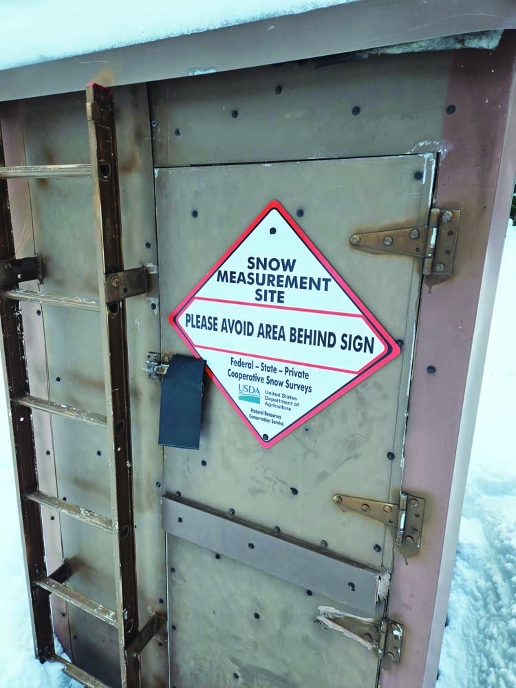
- A sign at the Tipton Snotel on Jan. 12, 2025, advises visitors to avoid the snowpack measuring station to avoid fouling up the measurements.
My endeavor to visit automated snow-measuring sites is much closer to quixotic than to Homeric.
A litany of lodgepole pine limbs trying to dislodge my eyeballs, rather than triumphant ascents of treacherous slopes to reach a stirring vista where I am inspired to compose sincere but awful poetry.
Mine is no grand quest.
There is none of the drama associated with a truly epic journey such as through-hiking the Pacific Crest Trail or trying to reach the highest point in every state.
(Topographic points, that is. I’ve often thought it would also be an interesting excursion to go to the top of the tallest building in every state. Alas, there is claustrophobia, to which I was immune for much of my life but which has spread, virus-like, over the past several years. My palms moisten if I so much as ponder stepping onto an elevator.)
I have no plan, as regards snow-measuring stations.
My method, such as it is, more resembles the Beatles’ Magical Mystery Tour (which wasn’t especially magical or mysterious) or the sort of rambling, no-itinerary sojourn that beatnik writers often took.
(Only without the hallucinogenics and the tie-dyed clothing. And I don’t drive a school bus.)
My singular concession to anything resembling a coherent concept is that I try to go when the snow stations are covered in snow.
Which, while obvious, does complicate the task.
Since most of the snow falls in the mountains, that’s where the stations are.
But in Northeastern Oregon during winter, traveling conditions in the backcountry have more in common with the Donner Party than with, say, Park City or Timberline Lodge.
Wheels, suffice it to say, are about as useful as kayaks.
What’s a Snotel?
The federal government started the Snotel network in the late 1970s.
“Snotel” combines “snow” and “telemetry,” the latter meaning a system of transmitting data from remote places. In the case of Snotels, the information is sent by radio waves and thence by digital means to the internet.
The purpose is simple — the stations track the snowpack, the biggest and most important water source for Northeastern Oregon and indeed for most of the West.
The basic method by which Snotels operate is straightforward, although the process involves the sort of equations that frighten and confuse me.
Each consists of a vinyl “pillow” filled with a liquid that doesn’t freeze even when the temperature goes well below zero.
(For all I know, this liquid is the same stuff you can buy at any auto parts store to top off a radiator that gets a case of indigestion while climbing Cabbage Hill.)
When we talk of snow we typically refer, of course, to depth.
“How much snow did you get last night?”
“Oh, 4 or 5 inches.”
(Or a more precise figure for those inclined go out into the yard with a ruler.)
But Snotels are designed to yield a different measurement — snow-water equivalent.
As the product of the federal government, which rarely describes something with a few simple words when several multisyllabic options are available, this term strikes me as nearly miraculous in its simplicity.
The snow-water equivalent, expressed in inches, reflects the amount of water that will trickle away when the snow melts.
Which obviously is what matters, if you’re a farmer or an angler or you just like to dip your toes in a stream or reservoir on a stifling August afternoon.
Most Snotels have been upgraded over the years with a device that, by means of a laser, also measures the depth of the snow atop the pillow.
But this statistic, although useful in estimating how long it might take you to dig out your rig if you get stuck in the vicinity of a Snotel, has less relevance when it comes to projecting the summer water supply.
That’s because snow, although generally white and cold, can vary dramatically in other characteristics.
A foot of feathery snow that falls when the temperature is near zero, for instance, might contain a small fraction of the water held in a foot of slushy snow that comes down when it’s 35 degrees.
Snotels reflect those differences.
The stations have largely, but not completely, replaced manual snow surveys for monitoring the mountain snowpack.
There are several places in the Blue Mountains, however, where people still trudge to a place, usually once a month during winter, to measure the snow.
Snow surveyors calculate the snow-water equivalent. But seeing as how it’s impractical, and I imagine exhausting besides, to haul around large vinyl pillows and gallons of antifreeze, they use instead a long, thin and relatively light aluminum pole and a set of handheld scales.
One surveyor plunges the tube into the snow, ideally all the way to the ground, then pulls it back up to extract a cylinder of snow. Surveyors weigh the cylinder (subtracting the weight of the tube, of course) and, by way of one of those terrible equations I mentioned, calculate the snow-water equivalent.
Snow survey courses — some of which, such as the one near Anthony Lakes, were set up in the 1930s — typically are in flat, open areas where the snowpack isn’t greatly affected by terrain or trees.
Surveyors take several samples along the course, which is usually a few hundred to several hundred feet long, and derive an average to account for minor differences.
Northeastern Oregon Snotels
The region includes about 30 Snotels, depending on how you define the Blue Mountains.
They are, naturally, concentrated at the higher elevations where the snowpack is particularly prodigious — the Elkhorns and Wallowas and the northern Blues. There are a couple Snotels in the Strawberry Mountains, too, and a few in the western Blues.
Many are far enough from a plowed road — several miles, in some cases — that a snowmobile is the most practical travel option.
(Except in wilderness areas, where motor vehicles aren’t allowed. However, because Snotels, despite their automation, require occasional maintenance by technicians who carry their tools in pickup trucks, almost all are outside wilderness areas. One exception is the Aneroid Lake Snotel, which despite its name is near, but not exactly at, that alpine lake in the Eagle Cap Wilderness south of Joseph.)
I have trudged in snowshoes to a few of the more accessible Snotels, those in and near the Elkhorn Mountains west of Baker City.
Two that are particularly close to roads are Gold Center, near the highway between Sumpter and Granite, and Tipton, just west of the summit of that name along Highway 7 about eight miles south of Austin Junction at Highway 26.
On Sunday, Jan. 12, my wife, Lisa, and I drove to the sno-park off Highway 7.
(This spot, popular among snowmobilers, is not part of the state’s sno-park system, so you don’t need a permit to park there.)
It was a nearly ideal day for snowshoeing.
The temperature was a few degrees below freezing and the wind so gentle that it scarcely moved the beard-like tendrils of lichen dangling from the pines.
There was a soft layer of snow, a couple inches deep, so our plastic shoes didn’t make the annoying clatter they do on crusty snow.
But during the previous 10 days or so of mostly tranquil weather, snow from the big storms between Christmas and the first week of January had solidified, so our snowshoes worked as they are supposed to, keeping us from plunging deep and making the excursion a pleasant sort of exercise rather than an exhausting, sweat-soaked ordeal.
I knew about where the Tipton Snotel sits. But 4 feet of snow buries most landmarks — roads, for instance — so I sort of meandered along, hoping we would see the station through the lodgepole pines.
The advantage of deep snow, of course, is that it covers not just landmarks but also the obstacles that litter the forest floor — logs with broken branches perfectly situated to gouge careless calves and thighs, for instance.
I appreciate the elegance of a well-designed hiking trail, to be sure.
But I also enjoy the freedom of choosing my own route, veering around thickets and tree wells and exploring little grottoes among the pines.
After half an hour or so we saw a small but conspicuous structure a couple hundred yards away.
Wearing a tophat of 3 feet or snow of snow, the building houses the controls for the Snotel, which consists of a couple metal towers suspending a solar panel, the laser for measuring snow depth and other paraphernalia that I’m sure perform some important function.
I checked online later in the day and saw that the Snotel was reporting 43 inches of snow. This seemed about right, although I had no intention of digging down to the ground.
(I didn’t have a shovel, for one thing. Or a tape measure.)
A couple signs advised people to avoid the Snotel itself. Because the station weighs the snow, a person who tromped on the pillow could foul up the readings both of snow-water equivalent and snow depth.
Although I’ve never read anything that suggests snowshoe hares and other forest dwellers can read, they seemed to have heeded the warnings. We saw no tracks, at any rate, on the pillow (or at least where I perceive the pillow to be, since we obviously couldn’t see it through 43 inches of snow). Tracks were abundant elsewhere, though, of both hares and squirrels as well as coyotes, the latter no doubt hoping to ambush either of the former.
The hike whetted my appetite for seeing other Snotels in their element, so to speak.
Those, however, will require much more exertion than Tipton demands.
If You Go
The road to the sno-park near Tipton Summit branches off from Highway 7 near Milepost 8, which is 8 miles north of Austin Junction at Highway 26, and about 41 miles southwest of Baker City. The road heads west. If you’re coming from Baker City, turn right, and if you’re heading north from Austin Junction, turn left. Follow the plowed road for about a quarter mile, then turn right for a short distance to the wide parking area.


