The Natural World: Pioneer pathways to the Umatilla River
Published 10:00 am Sunday, February 9, 2025
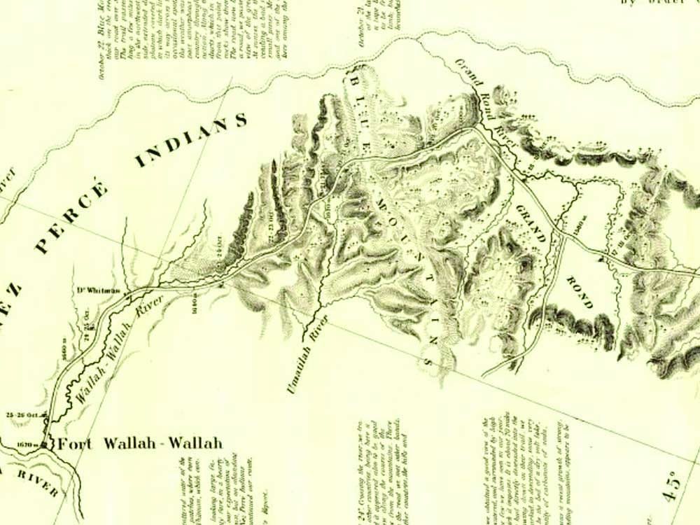
- Capt. John C. Fremont traveled along the Umatilla River headwaters to lead a topographic survey of the Blue Mountains in 1843, on the heels of the mountain man William Sherley (“Old Bill”) Williams.
The Umatilla River once served as an important meeting ground for the Cayuse and their Nez Perce allies to the east.
A large Cayuse settlement near Thornhollow kept hundreds of horses in the vicinity. An early historical record documents the Cayuse tribe hosting the overland party of Wilson Price Hunt, an agent of the fur trade, in 1812 where Meacham Creek meets up with the Umatilla River. As Hunt wrote in describing his route over the Blue Mountains: “On every side, were seen horse trails used by the Indians in hunting deer.”’
Several notable explorers crossed the Blue Mountains via the Umatilla River after Fort Nez Perces became established in 1818 near where the Walla Walla River met the Columbia River. For example, Nathaniel Wyeth and his expedition visited Fort Nez Perces via the Umatilla River in 1832 and again in 1834. The ornithologist John Kirk Townsend, known to Indian tribes as the “bird chief,” traveled cross-country from the “Utalla” to Fort Nez Perces in 1834.
In late August 1836, Marcus and Narcissa Whitman left the Grande Ronde Valley to cross the Blue Mountains via Fox Hill. According to one description, “The rivers and greenery of the Grande Ronde Valley and the Blue Mountains gave joy, while the terrain provided challenge and hardship.” The Whitmans’ route took them across Five-Point and Meacham creeks where they ascended Horseshoe Ridge and followed the route of Iskuulpa Creek downward to the Umatilla River. The Whitman party continued overland to the Walla Walla River and Fort Nez Perces, accompanied by John McLeod, a fur trader with the Hudson Bay Co.
Early on, the most direct route from the Grande Ronde Valley over the Blues was suitable for horse and foot traffic only. Timber had to be cut and removed to make room for wagons. Not until 1843 did settlers cut a wagon road, most likely following the 1840 route taken by Robert Newell and the mountain man Joseph Meek. Later that same year, Capt. John Fremont led a topographical engineering expedition across the headwaters of the Umatilla River after leaving the established emigrant trail, determined to find “a more direct and better road across the Blue Mountains.” Fremont continued north to a high point of the Blues near Baldy Mountain before turning west and traveling downslope to the Walla Walla River.
Between 1841 and 1847, the Oregon Trail’s main route to the Great Columbia Plateau and beyond stretched from the Blue Mountains to the western summit at Deadman Pass, where it descended to Emigrant Camp at Cayuse Springs. After resting at this bench of land at the foot of Poker Jim Ridge, many emigrants crossed the Umatilla River near the present-day hamlet of Cayuse. The trail took them northward across gently rolling hills to the Whitman Mission or Fort Nez Perces, where they resupplied before continuing their westward journey.
In 1845, the main Oregon Trail was rerouted to the west, and closer to Pendleton, following the Umatilla River downstream to Echo. The risk of encountering unfriendly Indians on the Walla Walla River route continued until the Treaty of 1855 was negotiated between the United States and the three area tribes: Walla Walla, Umatilla and Cayuse.
In his article “History of the Northern Blues,” Gerald Tucker describes another pioneer road that connected the upper Umatilla River to Summerville in the Grande Ronde Valley. The Thomas and Ruckle Toll Road was constructed in 1863-64 to divert business from Umatilla Landing to Walla Walla. The toll was $3-$5 per wagon and offered a more direct route to Walla Walla from Summerville via the Umatilla River than the Meacham Road. Farm products made up much of the traffic. The road also served as an important mail route from Boise to Walla Walla.
In 1864, a hand-hewn log inn was built as a stop for the California Stage Co. along the Umatilla River upstream of Gibbon. The three-story structure still is in use for guests who visit the present-day Bar M Ranch. According to local historian Sam Pambrun, the stretch of the Thomas-Ruckel Road that paralleled the banks of the Umatilla River from the Bar M to Thornhollow Grade was moved in 1867. The new route left the Bar M, climbed Ryan Grade to the north rim of the Umatilla River Canyon and traveled west to the top of Thornhollow Grade before continuing northward from Spring Hollow.
Tucker’s account describes how floodwaters washed out 14 miles of the toll road in 1886. This section of the road was not rebuilt until decades later. Ironically, another extreme flow event destroyed several miles of the same road along the South Fork of the Umatilla River in 2020, thwarting the flow of recreational traffic between the upper Umatilla River and Ruckel Junction.
Present-day motorists can follow much of the Oregon Trail route over the Blues by traveling Interstate 84 from La Grande to Pendleton. Snow typically clears from higher elevations by late May. The Oregon Trail Interpretive Park at Blue Mountain Crossing contains trail swales and scars on old-growth ponderosa pines made by passing wagons. The Whitman Route Overlook Trail No. 3095 can be accessed by taking the Mount Emily Exit onto Forest Service Roads 31 and 3109 to the interpretive area. A half-mile trail offers a panoramic view into Meacham Creek Canyon, where a railroad line created in the early 1880s hauls freight today.
Further west on I-84, the main watering point for Oregon Trail pioneers is on exhibit at Emigrant Springs State Park. A short walk leads to a view of marks left by covered wagons. Six rustic cabins are available for rent year-round. Campsites can be reserved from spring until fall. Distinct swales where emigrants passed can be viewed further west, at the Deadman Pass Rest Area, off Exit 228.
More pioneer history can be revisited by traveling Skyline Road (Forest Service Road 31), which connects I-84 at the Mount Emily exit to Highway 204 about 10 miles southeast of Tollgate. Spectacular wildflower viewing is in effect in early June, when Blue Mountain ridgetops burst into bloom of balsamroot, lupine and Indian paintbrush. The southern section of gravel road to Ruckel Junction is easily passable by passenger cars. The northern section, from Ruckel Junction to Highway 204, is paved. Overlooks provide expansive views of the upper Umatilla River canyon.
The North Fork Umatilla Wilderness Area can be explored downslope to the headwaters of the Umatilla River from Buck Mountain and Ninemile Ridge via trails that thread through stands of old-growth grand fir and 150-foot-high ponderosa pines. Forest Road 32 parallels the wilderness area along Thomas Creek to its confluence with the Umatilla River. Tread where members of the Cayuse once hunted game and foraged for roots and berries. Imagine the hardship suffered by Marie Dorian (the first white woman to cross the Blues).
Pretend you are a mountain man in search of fisher, beaver and bobcat. Take time to reflect on the rich history of the Blues and their abundant natural resources.


