Our View: Why GPS can be a lousy, even dangerous, winter driving guide
Published 5:00 am Tuesday, December 3, 2024
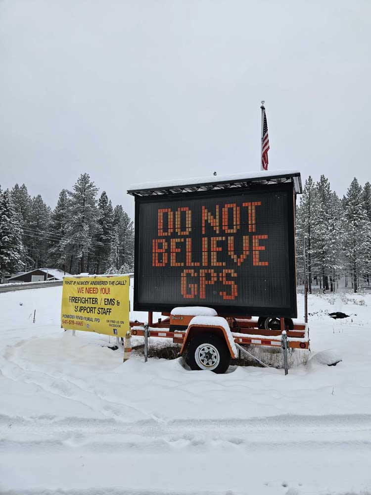
- An electronic sign in front of the Powder River Rural Fire Protection District near Sumpter is intended to dissuade drivers from getting stuck on roads that aren’t maintained during winter.
GPS satellites can pinpoint your position on the globe to within a few feet, an accomplishment that seems less impressive when your position is stuck in a snowdrift.
A snowdrift the satellites, which are immensely intelligent but also quite stupid, didn’t see.
The limitations of GPS are revealed regularly in Northeastern Oregon.
Most often nobody gets hurt.
But the potential for serious injury, and even death, is significant — for drivers lured into danger by this ubiquitous technology, and for their rescuers.
A characteristic case happened on Nov. 20 in Union County.
Interstate 84 was closed due to gale-force winds that had toppled at least one commercial truck.
About 20 drivers looking for a detour found one through GPS.
The road the digital scout suggested certainly exists; the satellites are pretty trustworthy in that respect.
But GPS doesn’t know that Ruckle Road, north of Summerville, is not maintained for winter travel. Which is to say, snowplows don’t go that way.
And as the drivers who continued along the road as it climbs into the Blue Mountains must have noticed, the snow has come early this fall to the Blues.
The vehicles, not equipped with tracks or capable of sustained flight, got stuck.
Fortunately, no one was hurt.
Members of Union County Search and Rescue, along with the Union County Public Works Department, helped the drivers get back to maintained roads.
Although the number of vehicles in the Nov. 20 incident might have been a record, the basic circumstances were nearly identical to more than a dozen episodes across the region over the past several years.
Not surprisingly, drivers are more likely to end up in trouble on paved roads that, when not covered in snow, can be reasonable alternatives to highways. (Although even many of these detours, due to steep grades and sharp corners, are ill-suited for 18-wheelers and other large loads.)
Almost every year, sometimes in fall and sometimes in spring, drivers get stuck on the Elkhorn Drive Scenic Byway west of Baker City and on the Wallowa Mountain Loop Road on the east side of the Wallowa Mountains.
Both are paved routes that aren’t plowed during winter.
GPS will readily include either road on what appears to be a straightforward itinerary, even when the snow is several feet deep.
The Oregon Department of Transportation and local officials are trying to discourage drivers from blithely following the digital breadcrumbs.
ODOT’s Trip Check website designates routes that are either not maintained during winter or that aren’t legitimate detours for commercial trucks when the freeway is closed.
Wes Morgan, chief of the Powder River Rural Fire Protection District in the Sumpter Valley of Baker County, uses two electronic signs to warn travelers about places to avoid.
One sign, along Highway 7 between Baker City and Sumpter, states that trucks should stay on Highway 7, a state-maintained road, rather than turning onto the Sumpter-Granite Highway, a paved road that is not plowed beyond Granite.
Morgan said during two freeway closures in November that sign failed to dissuade two truck drivers.
The second sign fulfilled its purpose in one case, but not the other.
This sign stands in front of the fire district’s station on the Sumpter-Granite Highway just west of Highway 7.
Its message is succinct: “Do Not Believe GPS.”
Morgan said one of the two trucks heeded that advice.
The other, however, continued through Sumpter and got stuck on the ascent to Blue Springs Summit between Sumpter and Granite.
The combination of online sources such as tripcheck.com and signs warning drivers that certain roads are closed during winter ought to convince most drivers to turn around before they no longer have that option.
But when that robust warning network fails, travelers might be left to rely on common sense.
Which, as debacles such as the Ruckle Road incident on Nov. 20 show, is not so common as we would like it to be.
Still and all, the reminder can’t be repeated too often.
When Interstate 84 through the Blue Mountains is closed, as it already has been and almost surely will be again this winter, the safest option is to wait.
Drivers who eschew that advice, though, can still come out unscathed, or relatively so, even if they don’t see, or choose to ignore, signs with blatant messages such as those Morgan set up.
If there are no tracks on a snow-covered road, no telltale berms on the shoulder showing that a snowplow has come this way, stop and turn around.
If possible — for trucks, in particular, it might not be.
If the road ahead doesn’t look right, it almost certainly isn’t.
And even if you, your confidence buoyed by the mapping app on your cellphone or dashboard navigation system, believe it will turn out OK, acknowledge that the absence of other traffic almost certainly is not a coincidence.
Also remember that GPS, for all its capability, is lousy at shoveling snow.

