The long way: Completing Oregon’s Blue Mountains Trail
Published 7:00 am Friday, September 29, 2023
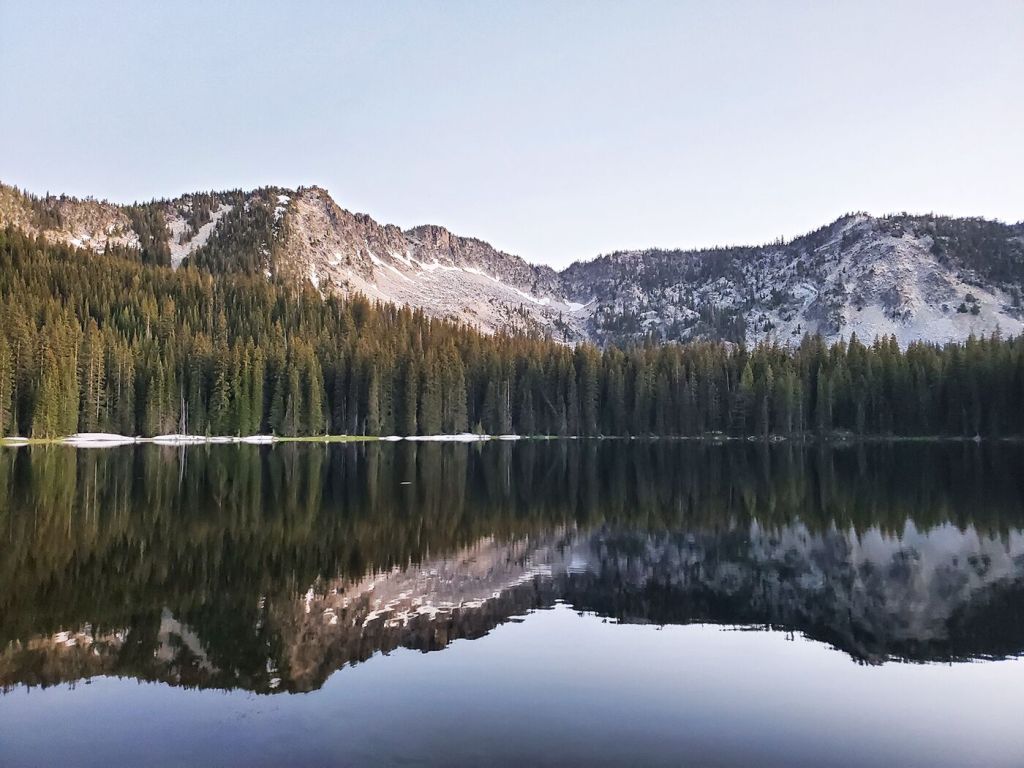
- Baldy Lake, near Mount Ireland in the North Fork John Day Wilderness, was one of Gill’s favorite spots on his Blue Mountains Trail thru-hike.
Riley Gill was cold, wet and a little bit worried.
High up in the Strawberry Mountains, the young man from Springfield was a couple of days into an attempt to become just the seventh known hiker to complete the Blue Mountains Trail, a challenging route that connects all the major mountain ranges in Northeast Oregon in a 530-mile spiral that starts in Joseph and ends in John Day.
Gill was hoping to become the first to complete the route in reverse, starting from the John Day end and hiking south to north. He was also tackling the trail earlier in the year than most might deem wise, starting in late June to take advantage of cooler temperatures rather than waiting until August or September.
His first challenge was the Strawberries, which still had significant amounts of snow in the upper elevations, especially on north-facing slopes. And after an unusually wet spring, storm systems continued to roll through the area.
On Day 2, he had to navigate a 10-to-15-foot snow cornice in the pass below Strawberry Mountain. On Day 3, a torrential hailstorm soaked him to the skin and chilled him to the bone. But Gill, an experienced long-distance hiker, was confident that if he could just make it through the Strawberries, the rest of the trip would be manageable.
“The whole Strawberry Wilderness there was awesome,” he said in a post-hike interview. “It was beautiful — but I was making sure I got out of there safe.”
Blazing the trail
The idea of a long-distance hiking trail showcasing Northeast Oregon’s most spectacular landscapes has been around since the 1960s, according to the Greater Hells Canyon Council, the nonprofit conservation group that spearheaded the trail’s creation. Planning began in earnest in the ’70s, but it would take another half-century of work by dedicated volunteers to complete the route.
The Blue Mountains Trail officially opened in 2021. No new trail was built in the process. Instead, the organizers stitched together existing trail systems with segments of road and a few sections of hiker-tested cross-country travel into a single route that looks like a giant backwards question mark with a few extra curves and wiggles thrown in.
The scope of the trail is breathtaking.
The route links all four of the region’s major mountain ranges — the Strawberries, Greenhorns, Elkhorns and Wallowas — as well as vast stretches of canyon country along the Washington and Idaho borders, including a dive into Hells Canyon, the deepest gorge in North America.
It traverses seven wilderness areas — Strawberry Mountain, Monument Rock, North Fork John Day, North Fork Umatilla, Wenaha-Tucannon, Hells Canyon and Eagle Cap, the state’s largest.
It rambles through ancestral lands of the Nez Perce, the Confederated Tribes of the Umatilla and the Confederated Tribes of Warm Springs, and it takes travelers through a crucial wildlife corridor that connects ecoregions of the Cascades, the Rockies, the Great Basin and the Blue Mountains.
Two years after opening, the trail remains a work in progress. The Greater Hells Canyon Council recently put out an online survey (www.hellscanyon.org/blue-mountains-trail) asking for feedback from trail users as well as business owners, community members and public officials in the towns it passes through in an effort to make the Blue Mountains Trail experience better for everyone.
And while there are no plans to build any new miles of trail (roughly 45% of the route uses remote two-track forest roads), organizers hope to make the route easier to follow by signing it with the Blue Mountains Trail’s rounded-triangle logo, which depicts a bighorn sheep against a mountain-and-canyon backdrop. Meanwhile, the U.S. Forest Service and groups such as the Blue Mountain Land Trust’s Blues Crew and the Wallowa Mountain-Hells Canyon Trails Association are working with the Greater Hells Canyon Council to schedule regular trail maintenance work parties.
“It was designed as something that would bridge the gap between recreation and conservation,” Megan Keating, the council’s development director, said of the trail.
“By putting our region on the map and highlighting this amazingly diverse ecoregion, (the hope is) it would inspire people to love it and want to protect it.”
Preparing for the journey
Born in Colorado, Gill got his first exposure to Eastern Oregon during a memorable car trip when he was 13. The area’s majestic scenery made a lasting impression.
“It was such a magical landscape,” Gill recalled. “I remember thinking, ‘I’ll be back someday.’”
True to his word, Gill moved to Oregon a couple of years ago, landing in Springfield and finding work with Yogi Tea, a Eugene company that makes a line of green, black and herbal “wellness” teas.
By that time, Gill (aka “Rabbit,” his trail name) was already an accomplished hiker of long trails, and his feet were itching to do some more.
He had previously tackled the 486-mile Colorado Trail and had his eye on the Continental Divide Trail, which follows the crooked spine of the Rocky Mountains for 3,000 miles from Mexico to Canada, before the COVID-19 pandemic scuttled that plan.
Since arriving in Oregon, he had completed the 40-mile Timberline Trail loop around Mount Hood and the 60-mile Corvallis to the Sea Trail.
And last year, he and a friend traversed 500 miles of the 750-mile Oregon Desert Trail before cutting their adventure short in the face of a major heat wave.
“It was getting life-threatening at that point,” Gill said.
But that trip set the stage for his Blue Mountains Trail hike. Renee Patrick, the Oregon Desert Trail coordinator and a long-distance hiker who goes by the trail name “She-ra,” had a hand in designing the Blue Mountains Trail and became the first person to do the whole route solo in 2020, a year before its official opening.
Gill credits Patrick with providing him much of the background information and firsthand trail intel he needed to plan his Blue Mountains Trail adventure.
“She helped me a lot with logistics, maps and stuff,” he said.
Making it work
As with most long-distance hikes, the logistics of trekking the Blue Mountains Trail can be daunting. There is a limited number of places along the 530-mile route where stocking up on supplies is practical, meaning hikers have to carry everything they need on their backs between those points.
Gill chose four resupply points, starting with Austin House, roughly 100 miles into the trek, where he mailed his first box of supplies. Other resupply points were at Sumpter, La Grande and Troy. After Troy, though, there’s really no practical place to restock along the route until the terminus in Joseph — a distance of 182 trail miles.
“That last section is huge,” he said. “That’s an eight-day carry.”
Gill started the journey on June 23 and finished on July 23, taking a couple of “zero days” (when he stayed in town and slept in a hotel bed) along the way and averaging around 19 miles a day.
Like many long-distance hikers, Gill has adopted a “fast and light” strategy, keeping the weight of his gear to a minimum in order to be able to cover long stretches of ground each day. He carries an ultralight backpack from ULA Equipment, keeps the rest of his gear as light as possible and doesn’t carry anything he doesn’t really need.
His base weight — the weight of his pack and its contents, not counting food and water — is 13½ pounds.
“That last section, from Troy to Joseph, with eight days of food, was the heaviest my pack’s ever been,” Gill said. “I’d say it was 27 to 30 pounds after resupply.”
‘What’s your Y?’
Gill was able to get the time he needed to hike the Blue Mountains Trail because Yogi Tea was temporarily shutting down operations to install some new production equipment. The company also helped cover the costs of his journey by making him a product ambassador, paying him to create photos, videos and blog posts about Yogi’s products during his time on the trail.
At two places along the route — Blue Mountain Outfitters in La Grande and Quickhatch Provisions in Joseph — he staged tea parties, where he gave out free samples of the company’s products.
And he was never without plenty of Yogi Tea in his pack, which he happily shared with the folks he met on the trail.
“You guys want some tea?” he would ask. “I’ve got lots and lots of tea.”
Gill would also ask them “What’s your Y?,” Yogi Tea’s current slogan, which he said sparked some fascinating conversations about passion and purpose.
“I met lots and lots of cool people,” he said.
Adapt and overcome
For Gill, the toughest part of his Blue Mountains Trail adventure was pushing through the challenges of those first few days.
The initial climb from John Day to the crest of the Strawberry Mountains — about 6,000 vertical feet — was one of the biggest of the entire trip. Then came that tricky snow cornice on the second day, followed by a series of thunderstorms that dogged his steps for the better part of a week.
“I knew if I got past the Strawberries,,” he said, “I should be able to get through the whole trail.”
And he was right.
Some of the other challenges he had expected to encounter by starting so early in the season — dangerous crossings of snowmelt-swollen streams or high-elevation trails blocked by snow in the Wallowas — failed to materialize.
Other difficulties he met and surmounted as they came up.
“The trail’s really new, so a lot of it’s not as well-maintained as I would have liked,” he said. “There were lots of blowdowns. Going that early in the season, a lot of trail crews hadn’t gotten out yet.”
There was more road-walking than he was used to, including one exceptionally long stretch between Tollgate and Troy, but that turned out not to be a problem.
“It’s kind of hard to complain when the road is, like, 60 miles overlooking a valley and you meet one person the whole time,” he said.
The trail has a few short sections that require hikers to do some cross-country navigation, but his route-finding skills were up to the task.
He had a few days where the mercury climbed above 100 degrees, but he dealt with that by finding a shady place to rest during the hottest hours of the afternoon. Even the mosquitoes cut him a break.
“I timed it just right,” he said. “Anthony Lakes was the only place they were bad.”
Highs and lows
And there were some truly magical moments along the way, Gill said.
He turned 29 a week into the journey, shortly after his first resupply at Austin Junction, in the vicinity of Vinegar Hill in the Greenhorn Mountains.
“I celebrated by sleeping in till 9 a.m.,” Gill said. “I also found a heart-shaped belt buckle that I carried with me as a spiritual talisman the rest of the trail. I still have it today.”
A few days later, he arrived in Sumpter just in time to catch the town’s Fourth of July celebration.
“I met some Squatchers,” Gill said. “They were playing drums and wind flutes and getting real spiritual about it. It was so cool!”
And the whole trail was a highlight reel of spectacular landscapes. Gill cited parts of the Strawberry Mountains, the Elkhorn Crest, Baldy Lake in the Greenhorns and the high Wallowa peaks as some of his personal favorites.
“(But) the best experience of the whole trip was dipping down from Buckhorn Lookout into Imnaha Canyon,” he said.
The view was so expansive, and the drop from the lookout into the canyon bottom so precipitous, that he started getting vertigo.
“That was so insane,” he said. “That was my favorite spot.”
But while the rewards of thru-hiking the Blue Mountains Trail were many, he added, they wouldn’t have seemed so sweet without the obstacles he had to overcome.
“The Blue Mountains Trail is the most perfect trail, in my mind,” Gill said.
“It was so special — the ups and downs, from thunderstorms to beautiful days — and that’s the way an adventure should be.”


